By Keith Millis
Surface restrictions to seismic acquisition pose an increasingly complex challenge to imaging desired targets. Some surface restrictions are time variant and require the acquisition team to be highly adaptable and responsive to changing conditions. There are aspects to nodal systems that can enhance this adaptability. Discussions on the benefits of nodal receiver infill stations can now be presented in the following case study on a recently acquired 3D dataset in Southern Alberta.
Initial planning for the program began after examining existing seismic datasets. During this stage it was determined that the program needed to image several targets; some of them were comparably shallower and required tighter line spacing to image adequately. In addition, the complexity of the target and desire for a robust dataset required a significant migration apron. These two conditions lead to a high trace density and large offsets, which together may be cost prohibitive. Acknowledging these issues, as well as topographical and landowner concerns, an operational decision was made to use a nodal (cable-free) recording system. The nodal receivers were lightweight, and easy to deploy making them ideal for use in operationally restrictive areas. Consideration of the effect this program would have on stakeholder’s perceptions of the energy industry was paramount. Pre-planning was based on Sustainable Resource Development (SRD) guidelines, and consultation with landowners on the program. While most surface restrictions are well documented, understood, and in the short-term static, sensitivity to stakeholder concerns meant the restrictions could be revised as the field work progressed. Using a nodal system allowed for radial rather than linear deployment of receiver stations along the lines. The full length of the receiver line need not be completely laid out, so long as the appropriate offset for any given source was available. Accordingly, the recording crew was not limited to acquiring the program in swaths. Potential offsets were not patch limited and instead only limited by what receivers were active. The associated advantages to processing in having long offsets in both the crossline and inline direction could now be pursued.
As surveying of the program progressed, several restrictions varied from what was originally expected. Many field conditions were refined by the survey crew, along with revised permit considerations. Field crews followed skid and offset guidelines when placing sources. Daily quality control of the surveyed stations allowed for real-time coverage modeling, and communication with the client. Notwithstanding the use of source restriction modeling, and more agile LIS drills, there were still areas where there were gaps in the coverage, shown in Figure 1.
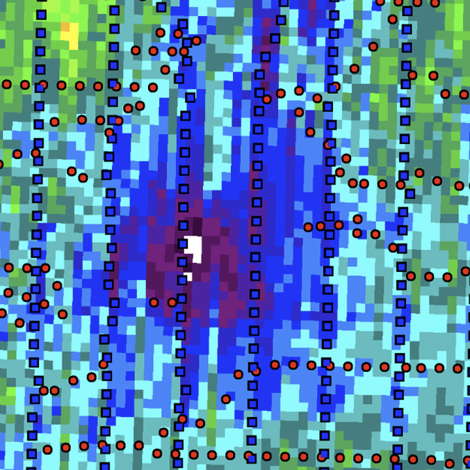
Figure 1 – Fold calculation in an area of the survey significantly affected by a source restriction. Sources are shown in red, conventional receivers in blue.
Though the restrictions were obstructive to sources, receivers – with a reduced environmental footprint – were able to be deployed in these restrictive areas. Stakeholder perceptions of the increased number of nodal receivers and their impact were well received, and no concerns with their deployment were presented. Through the detailed modeling of coverage in these areas optimal locations for nodal receivers were recommended, accepted, and deployed, shown in figure 2. Lead time between the survey and recording allowed mobilization of personnel to these key areas to install the receivers ahead of the recording crew.
At the time of this abstract, the seismic data was in processing and will be reviewed at the convention.
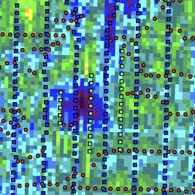
Figure 2 – Fold calculation same area as Figure 1 including receiver infill lines. Infill receivers are shown in the in green.
As seismic exploration continues in Western Canada, receiver infill stations, and nodal systems will be an increasingly important part of the acquisition arsenal. Infill stations are best suited to improving coverage in operationally restrictive areas. They were easy to deploy, their layout was not limited to full lines, and their flexibility meant the rental of additional equipment was not required to mitigate operational challenges.
The authors would like to thank Explor, SAExploration, Absolute Imaging, and SeisLand for the permission to use their data, and their contributions.